|
|
|
 UC-win/Road for xpswmm UC-win/Road for xpswmm |
We introduce a link tool that loads culculated result of floods analysis
software xpswmm to UC-win/Road using SDK which is for customizing UC-win/Road.
 Abut SDK (Software Development Kit) Abut SDK (Software Development Kit)
UC-win/Road SDK is an API (Application Program Interface) provided for various customization
of UC-win/Road. This API supports option developments control add menu,
topography, road, traffic, etc.
SDK for Ver.3.03.06 was released on the version up of UC-win/Road (Ver.3.03.06).
The version for Ver.3.03.06 supports unicode, and APIs on driving simulation
and create 3D model function were added.
This SDK will be supported by Delphi2007 on the version up of its package
Ver.3.04 planned on this summer.
About xpswmm
This is an integrated software which is available for physical representation
model to simulate flow quantity to the river and sewer system and its water
quality. xpswmm makes the measurement points mesh and output the depth
of water at each point as text file every career at each time. This tool
links using this text files.
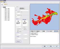
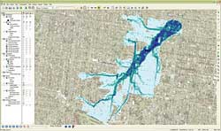
Tool outline
This tool provides function to UC-win/Road as pulg-in same as other tools
made by SDK. When this tool is used, the position that the result file
will be taken in is loaded as project in advance. Select Main menu - [Option]
- [Import xpswmm result data], import screen is shown. After select result
file and set the option, it is registered with UC-win/Road as a 3D model
every selected calculation result file and placed autmatically.
| 1) |
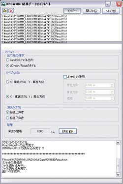
Select result file:
Select the time career result file outputted from xpswmm. Multiple selections
are possible. |
| 2) |
Option setting:
| - |
Select output location:
LandXML file and UC-win/Road are supported as destination. |
| - |
Direction of X-Y:
When coordinates and Depth at each mesh position are outputted to the result
file, the direction of X and Y can be selected from south, north, east
and west. The model is allocated to the center of the project, but the
allocation position can be changed using offset. |
| - |
Direction of Depth:
The direction of Depth can be selected from vertical upward and downward. |
| - |
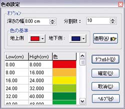
Layer:
Depth space setting and the color setting represents the depth position
are available. |
|
|
|
 xpswmm data import xpswmm data import
Color setting at layer |
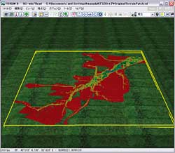
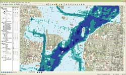
About 3D model created
3D model generator and allocation function, which are added to SDK this
time, are used to import calculation result file from xpswmm to UC-win/Road
as model. Load result file as 2D array, triangulate adjacent apexes and
hierarchize its center of gravity. If it's loaded to UC-win/Road as 3D
model, this hierarchy becomes leyer of the model.
Since the altitude of each top of model is take account for the Depth to
current terrain elevation, it is allocated on terrain automatically after
loaded. Loaded model can be controlled display or nondisplay on simulation
same as the normal model of UC-win/Road.
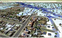
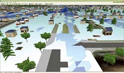
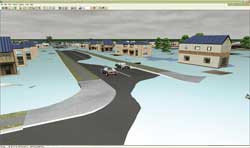
Effects
Importing the models per time history by this tool, flooding situation
per time history can be checked in VR by UC-win/Road script etc.. If landscape
is created in advance, the situation can be checked visually for 3D.
xpswmm
 |
|
 |
| UC-win/Road |
 |
Data conversion tool |
|
 |
|
 |
 |
|
 |
|
|
| Utilization of 3DSMAX data and plug-in development |
3DS format used in UC-win/Road can exchange data between 3D software very
widely. It has highly-compressible and VRML format was adopted on the first
edition of UC-win/Road, but it was changed to DS form in the early date.
See "The art of modeling and the texturing on 3DSMAX" on support
page of HP about the procedure and notes of creating model and texture.
Now, we introduce 3DSMAX plug-in developing in ASU (Arizona State University)
that is also user. 3DSMAX is used in various fields as universal 3D modeling
software of U.S Autodesk, Inc. In UC-win/Road, materials can be downloaded
by RoadDB, but the others are need to be create by 3D modeling software
etc.. 3DSMAX can map elevated portion and render reflection of light and
advanced textual effect in addition to 3D modelling. However, with the
aspect of quality and function of the rendering in the real time, UC-win/Road
has a higher tool kit.
It seems to totally compare an orange with an apple to compare these two
software, but for the typical client aimed for making of the presentation
using 3D model or cartoon film, the difference between an apple and an
orange is important. This plug-in maintains bidirectional compatibility
with UC-win/Road and 3DSMAX and enables effective link. The link of functions
such as the dynamic writing or surface reflection is considered and may
largely improve a sense of reality. |
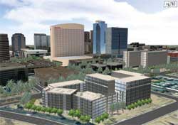
ASU, Desital Fenic Project |
|
| Utilization of Google Earth/SketchUp |
As many people may know about Google Earth(http://earth.google.com/), we introduce it simply just in case. This is the software that U.S Google
purchases the new software company in 2005 and started release free. You
can browse row of houses along a city street, relics, city etc. with a
high-resolution satellite photo image turning around the Earth with simple
and instinctive operational feeling. In addition, you can also view the
terrain data of mountain or valley and main buildings as 3D model.
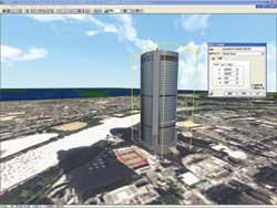
This time, we introduce building polygon data utilization of GoogleEarth
by UC-win/Road. Clicking the check box on "3D display of building"
layer of Google Earth, building of polygon is displayed. Many of these
polygons are white box model, but the building pasted texture is registered
with 3D gallery of Google and can be import 3D model.
We introduce the procedure to import model to UC-win/Road using Google
SketchUp pro 6 of Google. However, on this procedure, please pay attention
to the copyright of the companies, a licensing contract enough.
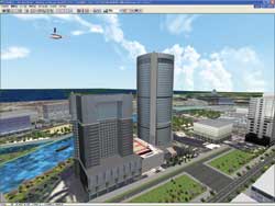
Google SketchUp 3DS model importing process
Export a 3D model of Google by 3DS file and allocate it in UC-win/Road.
(Sample:OAP tower, where there is FORUM8 Osaka office, and surroundings) |
| 1. |
Start Google SketchUp and press "Import model" button. |
 |
| 2. |
Select model which you want to import from 3D gallery and press "Download
model" button. |
| 3. |
Select [File] - [Export] - [3D model]. Set "Export format" to
3DS (*.3ds) and press "Option" button.
*Folder name and file name must be half size alphanumeric character. |
| 4. |
Select [By material] [Export textual map] from option setting items and
run it. |
| 5. |
Load 3D file saved with UC-win/Road. |
| 6. |
Allocate it on UC-win/Road which is pasted an aerial photograph. |
|
| * |
The sample data are the models that we created. The aerial photographs
are also owned by us and used on UC-win/Road. |
 |
| * |
For the use of the data of each product, please pay attention to the copyright
of the companies, a licensing contract enough. |
|
Google SketchUp Pro6 trial version download
The trial version possesses a complete function of Google SketchUp, but
use time is limited for 8 hours.
http://sketchup.google.com/
|
|
| Second Life data compatibility |
Second Life (http://secondlife.com/) is virtual society on internet and a lot different from online game so
far. The features are people can create games by themselves, Linden dollar
which is the currency in a game can be converted into money into actual
currency, etc..
We introduce the possibility of mutual data utilization of 3D model and
terrain data used in Second Life and UC-win/Road.
3D object of Second life
3D object of Second Life is created by editing basic 3D object which is
called prims. Second Life has simple and easy-to-understand editor, so it is relatively easy to create original 3D object by reproducing
an original prims object (a column, a globe, cube et al.) selected. By
this way, reasonably-complex 3D object can be edited/created.
Import/Export
It seems that Second Life can't import/export 3D object from/to other programs.
Plug-in to convert a 3D model into Second life seems to be developed by
some software developers and an earnest lover, but it is thought that it
is difficult to exchange data with UC-win/Road.
Many individuals and companies using Second Life require the expansion
of the kind of the handling file and wide import/export function. Wiki-architecture
community which exists in virtual environment of Second Life is also one
of the groups. Many users are interested in this project, but limited import/export
function is the problem and it is an obstacle of prevalence.
*Generally, product names and company names are registered trademarks or
trademarks. |
(Up&Coming '08 Midsummer issue) |
 |
|


>> 製品総合カタログ

>> プレミアム会員サービス
>> ファイナンシャルサポート
|