| The 4th 3D VR Simulation Contest Report |
| Holding Overview, History (Up&Coming 2006, Jan.) |
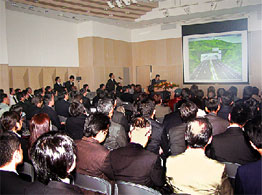
The 4th 3D VR Simulation Contest by UC-win/Road was held at Nakameguro GT Plaza Hall, Tokyo on November 22 in Forum8 Inc.
The hall is a public hall which is adjacent to the GT Tower building and
it was huge success that it was over 100 guests, full capacity.
Because this time there were so many entries, we held prejudging on November
10 and 10 works were nominated by our selection committee member. 3 works
in that 10 works came from China and Korea and we have brought out them
on the web site in that day. There were versatile business field for nominated
work, in which they were roads, bridges, rivers, ports, underground infrastructures
and constructions. More, there were a nominated work of traffic simulation
for large customers facilities using the traffic simulation function of
UC-win/Road and the work of information board simulation in the station.
We believed that the user and the participant there could see data with
delight. In the contest, it had 15 min. presentation for each work and
after the presentations, all users and 3 selection committee members(Mr.
Wada Tadaharu and developers of UC-win/Road) voted and selected by their
order points.
We have selected the data, "Matsuyama belt highway" by "Matsuyama
Bureau, MLIT" for the Grand Prix Award, "Tientsin Haihe bridges
project " by "CRISEN TECHNOLOGY CO., LTD" for Excellence
Award, "Dong Hong Cheun - Yang Yang highway project" by "Korea
Highway Corporation Basis Soft,Inc" for Oversea's Award and "Metropolitan
underground infrastructure model" by "NISSEI EBLO INC."
for Idea Award. This time we had many entries from overseas. We realised
that VR modelers of UC-win/Road were being developed in overseas. We will
hold the 5th its Contest with scale expansion in 2006 and we hope more
excellent work entry.
| The 4th 3D VR Simulation Contest |
|
 Nakameguro GT PLAZA Nakameguro GT PLAZA |

 GRANDPRIX GRANDPRIX
Ministry of Land, Infrastructure and Transport,
Shikoku Regional Development Bureau,
Matsuyama Rivers and National Highway Bureau |
|
|
   
 Matsuyama belt highway Matsuyama belt highway
 Ministry of Land, Infrastructure and Transport, Shikoku Regional Development
Bureau, Ministry of Land, Infrastructure and Transport, Shikoku Regional Development
Bureau,
 Matsuyama Rivers and National Highway Bureau Matsuyama Rivers and National Highway Bureau
|
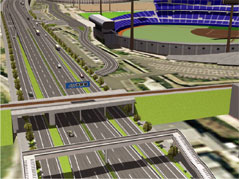
For the Matsuyama belt highway project, the main road, three ramps, one
JCT, survey road and several intersections are represented. A part of the
surrounding roads and streets were also created. The first local produce
placed as landmark is the Botchan stadium, some building are also placed
around the intersection.
In addition of being used for explanation purposes for the citizens, these
data will be used for the presentation new driving simulation system |
 |
 |
|
   
 China : Tientsin Haihe bridges project - Cifeng bridge design study China : Tientsin Haihe bridges project - Cifeng bridge design study
 CRISEN TECHNOLOGY CO., LTD. CRISEN TECHNOLOGY CO., LTD. |
Tientsin is a city of the North-East part of the plain of North China,
facing the sea and Bohai at the East side of the bay. It is the bigest
open shore of the North China and the economical center of Huanbohai area.
Haihe is the origin and the image of Tientsin and will welcome the 2008
Olympic Games. The restructuring project of Haihe is therefore and important
part of the development strategy of Tientsin.
The Cifeng bridge is at the heart of the development of Haihe and at the
center of the financial and business district of Tientsin. Next to Tientsin
station and East hand of the Cifeng road of Heping district and Haihe West
road, it links the Ligonglou interchange of Hedong district at the East
side. Since one road extends over Heping and Hedong districts, it becomes
the major link between the South-East part of the city and the Binhai international
airport.
Up to now, future developments for the Cifeng bridge have always been delayed.
Because its capacity is limited with the 10m wide structure and one way
two lanes traffic, peak hours see outbreak of chaotic congestions. Even
the separation of the up and downstream circulation in two bridges (Daguangmin
for the downstream) cannot restrain the traffic disorder.
The purposes of the project are as follow :
- Bridge design plan
Situation, traffic and especialy congestion situation.
- Passing method plan |
 |
 |
|
   
 Korea : Dong Hong Cheun - Yang Yang highway project. Korea : Dong Hong Cheun - Yang Yang highway project.
 Korea Highway Corporation Basis Soft,Inc Korea Highway Corporation Basis Soft,Inc |
These data represent the junction between Seoul and Yang Yang: Seoul-Chun
Cheun (61km under work), Chun Cheun-Dong Hong Cheun (17.5km under work),
Dong Hong Cheun-Yang Yang (71.5km design).
Aproximately half the complete length is modelized in UC-win/Road. The
first Korean highway modelized with computer graphics in Korea. |
 |
 |
|
   
 Metropolitan underground infrastructure model Metropolitan underground infrastructure model
 NISSEI EBLO INC. NISSEI EBLO INC. |
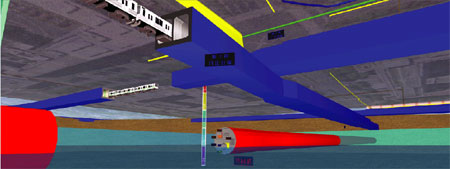
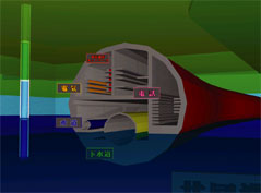
Creation of a metropolitan underground of the vicinity of a subway station,
including water supply and sewage pipes, gas pipes, and a complex representation
of the subway.
Representation of the different soil layers with gradation plans and a
depth gauge. The use of the fog in the underground increase the reality
of the model. |
 |
 |
|
 The Next place of the Contest ! We will hold it with more scale expansion.
Please expect it ! The Next place of the Contest ! We will hold it with more scale expansion.
Please expect it ! |
 |
|
tokyo conference center, shinagawa,
Big Hall A
JR Shinagawa stn. Minato-Minami Guchi |
 |
|
|
|
|
|


