|
Mr. Oshita, a teacher whom we interviewed this time, belongs to the Urban Design Area of the Community Planning Field, which corresponds to the conventional Civil Engineering field. His division of school duties is Research Department, being in charge of planning and operating the project seminars related to his specialty.
From this kind of perspective, he considers the most distinctive feature of the school's Project Seminar is that the students in the Community Planning Field can form a team with the students in the Manufacturing Field and the Preparatory Course to work on, for example, community collaboration using VR. To begin with, it should be rare for VR to be adopted in high school. Moreover, he explains its unique advantage that it allows the students to show their ideas in a tangible form and share them with outside parties and lead to new ideas.
Besides, Mr. Oshita also serves as an advisor to the Civil Club, which has about 20 members. In the club, members take part in the contest through surveying, bridge modeling, and concrete canoe building, as well as make a variety of efforts related to civil engineering such as contributing to the local community with VR. On the other hand, he is also an advisor for the rugby club, which has about 90 members, based on his experience as a graduate of Fushimi Technical High School, where he was a player of the rugby team that won the national championship in 2001 as a mainstay of the team in his junior year.
From Introduction of UC-win/Road to Its Use for Various Regional Issues
Mr. Oshita's first encounter with UC-win/Road dates back to 2014, when he was teaching in Fushimi Technical High School, the predecessor of Kyoto Kogakuin High School. He was originally using paper-based maps and GIS (Geographic Information System) through various initiatives in cooperation with the local community in his project research classes. In the process of exploring the possibility of using VR and other technologies, he came across an image of a class using UC-win/Road at first sight, being convinced of its interesting feature. Then he himself encouraged the introduction of UC-win/Road.
Since then, he has been teaching how to use UC-win/Road intensively during the first month or so of the Project Study (current Project Seminar) class as well as in the "Spatial Information Engineering" class, where students learn basic CAD, GIS, and VR operations in rotation. In the first year, FORUM8 staff served as a co-instructor, and since then, Mr. Oshita has been leading the class as the instructor in charge under the continuous support of FORUM8.
"High school students today are able to learn and create things of a certain level on their own after we first teach them a little about how to place models and create data," he says. In fact, after teaching the basic operations of UC-win/Road, the students are surveying and photographing the roads and creating VR for themselves, says Mr. Oshita.
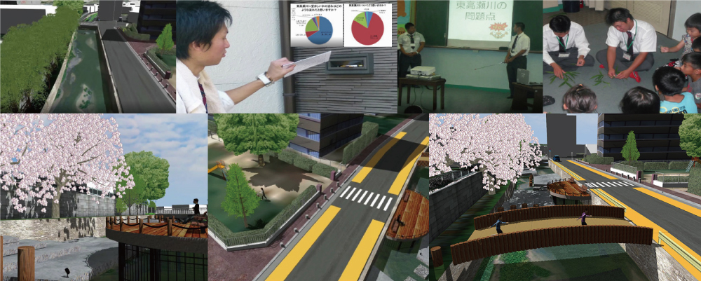
For the Project Study in the first fiscal year when UC-win/Road was introduced (FY2014), the students shared their research project on the Higashitakase River, which flows near the then-Fushimi Technical High School, through meetings with local residents in the neighborhood and fieldwork in terms of traffic, disaster prevention, and scenery. Focusing on the regional needs on landscape, the students used VR to simulate ideas for improving and upgrading the environment around the river. Based on the results, the students challenged the 3D/VR simulation contest and won the Second Prize.
In the same class in the following fiscal 2015, they also studied the measures to improve the environment around the Higashitakase River with the elements of disaster prevention and construction in addition to the landscape for the previous year. In order to make a more realistic proposal, the students conducted investigation about heavy equipment usable in consideration of the flow calculation based on the river cross-section and the width of the surrounding roads. Based on these, the students proposed a space where local residents could gather. They finally won the Essence Prize in the same contest.
In fiscal 2016, when the integration and relocation to Kyoto Kogakuin High School were made, the Project Seminar class allowed the students to create 3D data about the former Fushimi Technical High School building to pass it down for future generations, using UAV (unmanned aerial vehicle) etc. to reproduce it in 3D VR. In the same contest, they again won the Second Prize.
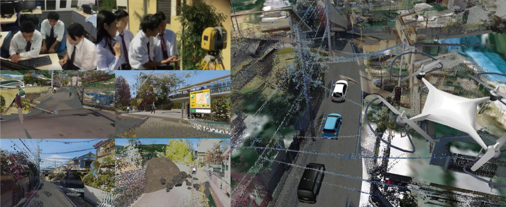
In the same class in the following fiscal 2017, the students created point cloud data about the environment around the school through UAV photography and SfM analysis. Then they proposed to create VR work of emergency disaster response that would be useful for evacuation and the supply of relief supplies in the event of a major earthquake. This work won Honorable Judge Award Chiikizukuri Award (Community Development Award) in the same contest.
3D VR Simulation Contest on Cloud Awards
The Second Prize (Excellence Award) for the 13th Contest (2014)
"Simulation for environmental upgrading around the Higashitakase river" |
The Second Prize (Excellence Award) for the 15th Contest (2016)
"Fushimi Technical High School, our alma mater to pass down for the future generations" |
 |
 |
| After hosting an explanatory meeting for residents, students posted a questionnaire form to every resident to seek their opinions for community development. Based on the residents' opinions, students created an improvement plan using VR with the aim of restoring the river to a clean river where fireflies can live, and children can play. |
With a strong desire to preserve the historic school buildings for future generations, students reproduced the school as VR data by drone filming the parts of the buildings to be demolished that are difficult to film. |
Honorable Judge Award Chiikizukuri Award (Community Development Award) for the 16th Contest (2017)
"A proposal for the emergency planning using VR for huge earthquakes" |
Essence Award for the 18th Contest (2019)
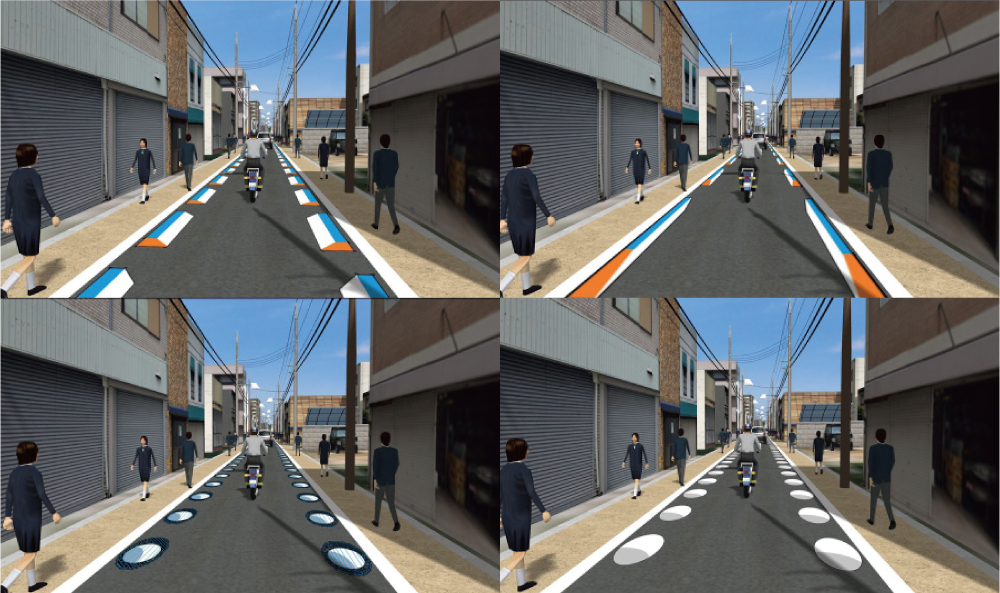
"DS simulation of speed hump marking at Honmachi-dori street" |
 |
 |
| In the event of a major earthquake, the damage situation can be assessed immediately by using drone photography. Students proposed VR for emergency disaster response that would be useful for damage prediction, disaster evacuation, and delivery of relief supplies. |
During a local disaster drill, students proposed a simulation showing the effect of vehicle speed reduction by speed hump markings on a narrow school road to the residents for them to experience. |
Honorable Judge Award Project Award for the 17th Contest (2018)
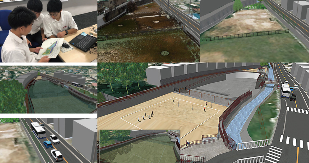
"VR data utilized for the Nanase River renovation plan" |
|
 |
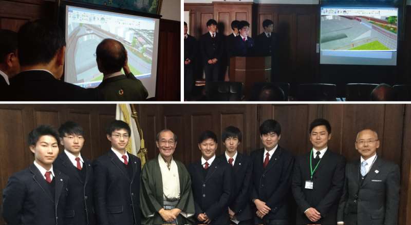 |
| In January 2019, students presented the VR data that demonstrates an effective use of the renovated retarding basin at Kyoto City Hall in front of the Mr. Kadokawa, Mayor of Kyoto City (centre, bottom right photo), the chairperson of the Urban Planning Committee, the Director of the Construction Bureau, the Director of the Civil Engineering Technology and Disaster Management Bureau, etc. The presentation using UC-win/Road included a comparison of the environment before and after renovation, and water level rise due to changes in weather conditions and water level in an intuitive way. |
|
Also in fiscal 2018, the students were asked by River Improvement and Maintenance Division, Bureau of Construction, Kyoto City to create a VR work for community briefing on the Nanase River Improvement Project, which was used in the actual briefing and also presented to the mayor. They won the Honorable Judge Award Project Award for this data in the same contest.
In addition, in fiscal 2019, the students in the same class used VR to represent Honmachi-dori Street near the school, which is a one-way street with narrow widths and heavy traffic. They developed a driving simulation that explored the effects of deceleration of vehicle using various image humps. They also won the Essence Award in the same contest.
Impressions of UC-win/Road and Development of Its Use by the New Third-year Students
"We use UC-win/Road mostly in the Project Seminar class, except in the case of the Civil Club.", says Mr. Oshita. In light of this situation, we asked four new third-year students in the Urban Design Field about their use of UC-win/Road. First of all, three of the four students experienced UC-win/Road for the first time in the first year of Community Planning Field, in demonstrating design of a park in the VR space in choosing either of the Urban and Architecture Areas as their specialty.
According to one of them, Ms. Hasegawa, when she expresses her idea in a drawing, it usually has to be planar, whereas she can express it three-dimensionally when she uses UC-win/Road. Through this, she has realized that it is easier to understand and more imaginative. She mentions its potential as a means of communicating information, such as when teaching directions to small children.
Ms. Murao also described the use of VR as a valuable experience that she cannot have at other schools. She pays attention to its feature that it is easier to visualize and imagine than to think in one's head, and it is also easier to grasp the sense of distance. She also expects for the fostering of a practical awareness of crisis led by the increase in opportunities to see the VR in a way that is relevant to daily life as a disaster prevention measure, such as tsunami predictions.
Furthermore, Mr. Nishikawa expressed that what he imagines in his mind can be depicted like a miniature in VR. He then recalled that a "good era" has come where imagination can be visualized in three dimensions. He also envisions the creation of new convenience from the pedestrian's point of view by creating the interior of a public facility using 3D VR and linking it with a map application.
On the other hand, Mr. Taniguchi, who experienced UC-win/Road ahead of others at a school information session when he was in junior high school, was impressed by the fun of creating an original park and conceived for further utilization. He is considering the development of driving simulations with content that contributes to traffic safety, which can be experienced on a PC at home.
Anticipating the Growing Need for VR, Looking to VDWC as a Challenge
"I highly recommend it as a tool to give shape to ideas in a class where students set problems and propose solutions," he said. Mr. Oshita particularly notes the ease of use of UC-win/Road, owing to its compatibility with other software such as CAD. In addition, he recalls that participation in 3D/VR Simulation Contests, which initially raised concerns that the hurdles might be too high, has been a positive stimulus for the high school students, stimulating their willingness to take on new challenges.
Under such circumstances, some teams in the recent Project Seminar have started to try to develop their own metaverse by creating VR using UC-win/Road. Mr. Oshita says that he doesn't tell them anything like "why don't you do like this", as the activities of Project Seminar is left to the autonomy of the students. However, he believes that if students can make concrete proposals based on the results of the class, which is designed to solve problems, it may lead to supporting DX (Digital Transformation), which is required of engineers in the future.
In addition to the aforementioned Simulation Contest, he also mentioned his hopes for challenging the "Student BIM & VR Design Contest on Cloud (VDWC)" (also held every fall by FORUM8). However, he pointed out that it's even more difficult to overcome, requiring the use of multiple specialized software programs and presentations in English, for example. In order to clear these hurdles, it is essential for students to be willing to go out and learn the necessary knowledge and skills on their own. He says that this is exactly what the class aims to achieve.
|
What's more, Mr. Oshita explains that knowledge and skills about VR will become increasingly important after graduating high school in the field of civil engineering, especially as BIM/CIM application accelerates, not to mention its effectiveness as a proposal method through classes.
"It's as a matter of course that basic civil engineering techniques such as surveying are necessary, but VR is evolving year by year and how to use it should also change accordingly. Therefore, I believe we must conduct classes that respond to such trends."
|
 |
| Mr. Oshita with new third-year students in the Urban Design Area |
|
|
