|
Kansai University is composed of 13 faculties including Law, Letters, Economics, Business and Commerce, Sociology, Policy Studies, Foreign Language Studies, Health and Well-being, Informatics, Societal Safety Sciences, Engineering Science, Environmental and Urban Engineering, and Chemistry, Materials, and Bioengineering; and 16 graduate schools including Law, Letters, Economics, Business and Commerce, Sociology, Informatics, Science and Engineering, Foreign Language Education and Research, Psychology, Societal Safety Sciences, East Asian Cultures, Governance, Health and Well-being, School of Law, School of Accountancy, and Graduate School of Professional Clinical Psychology. Over 30,000 students are studying in total in both undergraduate faculties and graduate schools with 740 full-time teachers (as of May 2017 for both). The university has 4 campuses in Senriyama, Takatsuki, Takatsuki Muse, and Sakai, and other multiple educational and activity bases.
Prof. Kusumi took a position as the President of Kansai University in October 2009. His term continued for 7 years by September 2016 (for 2 periods). Since the final year (2016) was the 130th anniversary of the Univ., the following centers were established as its commemorative projects: 1) “Center for Innovation and Creativity”, a collaborative and joint research base for faculty members, students, companies, and research institutes across the boundary between arts/humanities and science courses, 2) “Research Center for Naniwa-Osaka Studies”, which constitutes a hub for regional studies mainly on Osaka. In particular, the latter was started with willingness to study culture of Osaka, which has contributed to the development of the University.
Major Three Fields Studied by the Lab
"Geo-Environmental Engineering Laboratory", which Prof. Kusumi
teaches saying, "Its main focus is (studies on) rock slope",
does research with three major fields of 1) rock slope, 2) groundwater,
and 3) detection of cracks on tunnel wall surface. During the period of
7 years when he was serving as the President, several specially-appointed
professors supported the lab on his behalf. For a year and half after he
came back, the lab has been doing research with main focus on research
on detection of cracks on tunnel wall surface using AI (artificial intelligence)
and that on groundwater in Ono-shi, Fukui, stated later. Currently, 2 graduate students and 6 undergraduate students belong to the lab. At least 1 PC (personal computer) is secured for 1 undergraduate student, and 2 or 3 for 1 graduate student for using various software programs including numerical simulation and data processing of field surveys.
|
One of the issues that attract his attention regarding rock slope is slope stability construction method in consideration of landscape. While a common slope face with mortar spraying does not consider landscape so much, this aims at slope stability, for example, without cutting down trees on the natural slope as much as possible.
To establish a retaining wall construction method that has no adverse effects on landscape (including environment) by leaving trees as they grow, though the degree of slope stability becomes lower than that realized by the mortal spraying method, and yet prevents serious slope failure, laboratory experiments and field studies have been continued.
|
| |
|
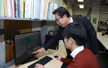
In addition, according to the Road Law revised following the ceiling board collapse accident of the Sasago Tunnel on the Chuo Expressway (2012), and road facilities such as tunnels and bridges are required to have regular inspection once in 5 years. However, there are a huge number of those types of facilities across the nation. Moreover, there are some constraints on conducting inspection, for example, with hammering inspection; therefore, actually operations are not keeping up with the needs. Thus, in order to detect cracks on the tunnel wall surface accurately and quickly, he and others devised a method of shooting the entire tunnel wall surface in succession with high-definition photos and utilizing “Convolutional Neural Network (CNN), a type of machine learning of AI for image processing of the photos. They are proceeding research to establish a highly accurate detection method without discrepancies.”
|
|
 |
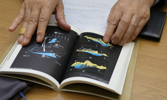
Furthermore, regarding groundwater, they have been focusing on Kyoto Basin for nearly 30 years. They examine proper maintenance methods so that this abundant groundwater can be utilized permanently without exterminating it, and conduct seepage analysis and advection diffusion analysis to solve various problems of groundwater.
In such processes, in 2002, when a TV program of NHK picked up traditional
ways of utilizing groundwater in Kyoto, he reproduced the situation of
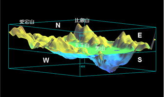
underground of Kyoto Basin with 3D CG as a method to convey part of engineering
research results of Prof. Kusumi in a way easy to understand. At the same
time, he mentioned the fact that about 21.1 billion tons of the amount
of groundwater reserves of Kyoto Basin can be compared with that of Lake
Biwa, which is considered about 27.5 tons. That program suddenly made the
huge-scale water resource lying underground of Kyoto (which he calls "the
Kyoto Suibon (Kyoto Water Basin)") an object of attention.
|
 |
|
3D structure model of the Kyoto Suibon (Kyoto Water Basin:
large amount of water reserve under the ground of Kyoto Basin) |
Doing Research on Groundwater in Ono-shi, Utilizing UC-win/Road for Integrated Visualization of Above and Under the Ground
A point of contact between Prof. Kusumi and UC-win/Road dates back to about
5 years ago. When he was serving as the President of the Univ., in considering
measures to revitalize towns in Osaka for a long time, he developed his
idea that though Osaka had been called "City of Water" since
long ago, landscape in the surrounding areas of the Dojima River, Nakanoshima,
and the Okawa River had been spoiled by crossing with the overpasses of
Hanshin Expressway etc. When he had a chance to talk with Professor Shigenori
Tanaka, Faculty of Informatics of the Univ., he expressed his thought.
Then Prof. Tanaka united his own research with Prof. Kusumi's idea. As
a result, a VR simulating the landscape of the concerned area was created
using UC-win/Road.
In April 2017, a research activity started in which Kansai Univ. cooperates with regional revitalization of Ono-shi, Fukui. As part of this, Prof. Kusumi took responsibility of engineering approach for utilization of groundwater. He took this opportunity to prepare a plan that contains introduction of UC-win/Road based on his success experience in VR in the past.
With urban areas that spread over the basin preserving the appearance of
the old castle town, Ono-shi has a similar characteristic to Kyoto, both
of which have been utilizing abundant groundwater in daily life to the
full since long ago. Reacting to the city's intention to emphasize the
groundwater to revitalization of the region, 4 researchers and faculty
members of Kansai Univ., who study town revitalization with different specialty
from each other, joined the project. Regarding the groundwater of the city
that was the basis for a series of activities, first, Prof. Kusumi decided
to quantify the amount of groundwater reserves of the basin, water balance,
and situation of utilization of water. Second, he targeted visualization
of their results in a way easy to understand using 3D VR.
|
 |
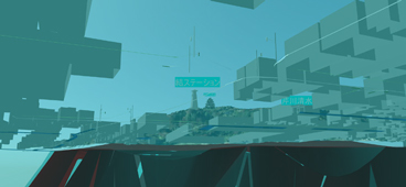
| Groundwater research of Ono-shi, Fukui prefecture |
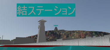
Literally hidden under the ground, the groundwater cannot be seen so often usually. Thus, Prof. Kusumi formulated the following plan. The data is created with VR included the ground surface of the actual region, reflecting multiple places of springs within the urban areas and the concerned areas centering on Ono castle. At the same time, VR of the underground is also created reflecting the geological constitution, places of the groundwater reserves and their conditions. Then these VR of above and under the ground are matched so that relationship between the geological constitution and springs etc. can be correctly represented and connected to integrate them as a whole and visualize them.
In doing so, UC-win/Road is basically capable of representing both above
and under the ground with 3D VR. "However, at present it is impossible
to treat the underground (creation of VR that reflects geological elements)
with only UC-win/Road". Therefore, he prepares a 3D geological analysis
software program separately.
On the other hand, although related materials and data such as boring logs owned by municipalities are utilized, data necessary for correctly grasping the whole aspect of aquifers and bedrocks is considerably lacking. Regarding this, he and others are supposed to complement by obtaining data by themselves. They are planning to work in order to improve the 3D geological constitution, the whole aspect of aquifers, the amount of groundwater reserve, water balance etc. into more accurate ones.
"(In building up a platform for examining regional revitalization)
since anything can be planned on the assumption of estimations, it is important
to have correct input data (to avoid such a situation)."
|
 |
|
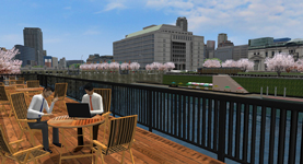
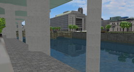
Proposal of a plan for taking Hanshin Expressway underground and improving urban fascination using VR
Present condition where an overpass and bridge piers block the view, and
the image of developing a water space by moving them underground in contrast |
|
 |
|
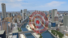
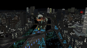
VR of creating future landscape of the surrounding areas of Tenjinbashi
Future landscape with a Ferris wheel installed in Kensaki area for creating
bustle in Nakanoshima, and an image of enjoying illuminated night view
from the Ferris wheel |
|

