UC-win/Road Ver.3.4, new version is scheduled to be released in a few days.
This section describes "New function of UC-win/Road" and "Intersection Texture Edit Tool" which have been introduced in this old issue.
This function allows you to define an environment with a driving simulation. It allow you to control VR environments matching a driving situation. For example, VR effects on the introduction of road development projects or road infrastructure projects. And special event settings allows you to use for a driving diagnosis or education. All simulation patterns will be supported in near future, for the scenario function supports mainly driving simulations in this version.
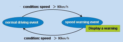
The function, a scenario flow can be controlled, has been developed with reference to finite automaton. To use this, you set a scenario "Event" and "Condition". Active event show a state of a scenario and the condition define a state transition. The event activates when a driving condition meet the condition you defined. After the event happening, other condition finishes the event. A complicated action can be set by simultaneous processing of multiple combined conditions and multiple events.
 |
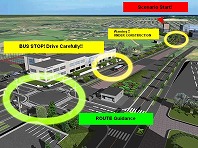 |
"Event action" allows you to control an environment or play multimedia.
-Environment control: moving object, traffic signal, movable model
-Multimedia: message, image, sound, video
The scenario condition can be set by using driving speed, contact with a 3D model, elapsed time, passing points and keyboard operation.
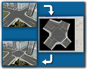
Road grade crossing has been improved. UC-win/Road recognize a grade crossing and a road as a separated 3d model. After creating two textures of a road and an intersection, you need to smooth out two model surface of these textures. You needed to create intersectional textures with external applications in traditional version.
You can not refer to road structures, cross sectional shapes, aerial photographs with external application. Therefore, the problem occurred frequently, when the textures are reflected to UC-win/Road. The additional labor was required for repetitive tasks. General graphics editing tool doesnft support a road marking, especially an intersection.
-Straight line, Polygonal line and Polygon
Straight line, Polygonal line and Polygon can be created with straight line or 0ezier Curve. These are handled as vector data like CAD software, the created figures can be edited, copied and grouped.
-Auto texture creation
It allows you to create automatically a borderline of a road surface, a gap of a traffic line, center line and white line.
-Combination of basic figures
A stop line, a crosswalk and a zebra zone are easy to create with the macro, which is a combination of basic figures. Settings, such as a parametric, a line width and interval between a broken line and a zebra, allow you to create a marking compatible with a design criterion of intersection.
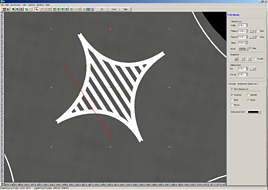 |
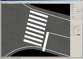 |
-Grouping and Library of figures
It allows you to group a figure you created before, and you can resister the figures to a figure libraries. This library allows you to re-use a bicycle, a pedestrian, a symbol like a warning sign.

-Color Adjustment Function
Road surface color can be matched to cross-section textures.
-Layer
Layer display is supported same as a CAD software.
It allows you to display/ hide a peripheral road, a terrain, an aerial photograph, a baseline can be displayed / hidden.
This tool is upgraded of convensional version. Previously only a rectangular parallelepiped was able to be created. Now optional 2D shapes with optional height is available. 3D models to be created consists of multiple prisms.
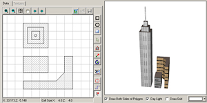
Shapefile plug-in(paid plug-in) allows you to export/import models. It supports you to draw a figure correctly with grid-snap, right angle snap functions. A simultaneous setting of wall and roof textures shorten your timescales.
UC-win/Road Ver.3.4 supports full-screen display by hiding title bar, menu bar , tool bar and status bar. This is useful when you experience a driving simulation or VR space. A screen manager can put to the status of screen which is recorded at the time of starting UC-win/Road back. And it also records the main screen to display VR space, display of back and right and left, status of 2D view. In addition, it records the status of saved landscape view of each VR data. This become easy to switch display/hide of set view. Operatablity was improved by integrating frequency used functions together in one simulation panel on presentations. Added in this version; -move button of a camera -drawing option -traffic and driving simulation -model placement -switching to the draft mode -run and edit of a script -screen capture UC-win/Road 3.4 supports Microsoft Windows Vista R. UC-win/Road folder structure was needed to be changed for enhanced OS security. Although all data was managed in the installation folder before, a user-designated folder become available. Administration of authority and registry become available for multi users account. HTML help is adopted for a users manual, while WinHelp was used before. SDK can be handled with CodeGearTM Delphi 2007, Delphi new version. not supported for conventional version. Added; OpenGL display customizing for vehicle motion model control of MD3 characters creating of 3D models callback of click operationB |
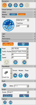 of simulation panel |
