New Products & Service Simulation 
VR-Cloud® NEXT and new cloud service
CIM-conscious new cloud solution
●Price
●Release
TBD
2019

 Introduction
We are redesigning and newly developing cloud program so that FORUM8 product users can take an advantage of them in more situations. Lately, we relaunched the free scientific calculator. We are developing products to provide the centralization of information management realized only because of cloud and the accessibility to information and functions by using state-of-the-art web technology.
 Basic F8 Cloud Solution Eco System
Centralization of information management service equipped with GIS function
The purpose of this service is to store, share, and manage data. Its multiple search methods treats (1) geographic data, (2) property, (3) general folder construction.

In addition, sharing parts and data models that are often used enables the reuse of data and the simultaneous data update.
This makes a system useful for storing large VR data, design and drawing data, and measurement data.
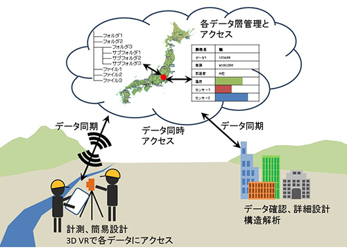
Fig.1 Data sharing system

Data compatibility
even if it is a web app or app for tablet and smartphone, data compatibility with desktop application is basically ensured for products having the same purpose. This reduces the number of files to be used, and the same data can be used in any application. It is important not only for the compatibility but also for the management of data change history.

Simple entry
This time, we will develop a simple entry version web application of the current products so that users can review structures immediately in construction sites. The way of entry is simple, but the calculation is executed in the same way as the current normal program. The data with compatibility can be handled in office too.
 VR-Cloud® NEXT
VR-Cloud® NEXT is a project name, and one of the purposes of it is to enable to use 3D VR data created in UC-win/Road wherever and whenever like the current VR-Cloud by using new cloud solutions. 3D data files stored on cloud can be handled in many formats for reference and management of property data. For example, FORUM8 will progress IM&VR to next step by using a system suitable for CIM.

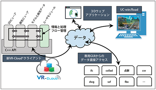
Specifically, users use applications they need from this system configured of multiple apps centered on data (Fig.2).

The basic configuration of this program is the cooperation between UC-win/Road, 3D web application, and new VR-Cloud® client via new data service. In addition, users can manage each model data as separated file and use each application independently.

The new VR-Cloud® client has a crossed-platform 3D engine and is developed with independent processing modules and GUI modules on common C++ API. The enhancement by API makes it a platform being able to correspond to needs flexibly.

Fig.2 VR-Cloud® NEXT

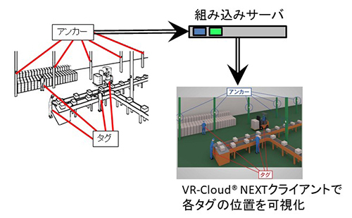
The figure 3 below is a study case of application developed on VR-Cloud® NEXT, the configuration combining Ultra Wide Band tagged VR real-time location data system, embedded system, and VR-Cloud®.

Fig.3 VR RTLS
Visualize positions of each tag on VR-Cloud® NEXT client.
 Future plan
We are now mainly developing GIS mounted data cloud service, VR-Cloud® NEXT, web version of RC section calculation, and web version of Box culvert design calculation. The initial release of data cloud service and VR-Cloud® NEXT is planned in the beginning of 2019.
(Up&Coming '18 Fall issue)
Back
Up&Coming

FORUM8