Home Back
Introduction Programs

  12d Model Powerful surveying and civil engineering software package

Latest Ver.: '09.12.18
Windows Vista/7/8/10
12d Model Open price
UC-win/Road 12D Model plug-in US$750 (Tax is not included.)

ProductPrice/PurchaseSample

  Screenshots
ライン

Click to enlarge the image.
■ 12d Model sample case


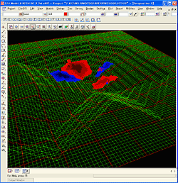
Measuring the terrain of the lake bottom at intervals, coloring the sediments (or the deep place), and displaying it on the bottom terrain.

-Green mesh : Terrain of shore and bottom
-Blue area : Areas where sediments are piled up.
Well-colored place shows more deposits.
-Red area : Areas where sand is scraped.
The deeper the color is, the more sand is scraped.

The places to be colored are determined from the difference between the terrain created from the previous result and that created from the current result.


Click to enlarge the image.

Click to enlarge the image.


Click to enlarge the image.

Click to enlarge the image.

Click to enlarge the image.

Click to enlarge the image.

Click to enlarge the image.

Click to enlarge the image.

Click to enlarge the image.

Click to enlarge the image.

Click to enlarge the image.

Click to enlarge the image.

Click to enlarge the image.

Page Top Page Top

FORUM8